Category:Notting Hill
Jump to navigation
Jump to search
area of London, England   | |||||
| Upload media | |||||
| Instance of | |||||
|---|---|---|---|---|---|
| Location | Royal Borough of Kensington and Chelsea, Greater London, London, England | ||||
| Area |
| ||||
| Different from | |||||
 | |||||
Subcategories
This category has the following 56 subcategories, out of 56 total.
A
B
C
- Clanricarde Gardens (4 F)
- Colville Terrace (9 F)
D
- Denbigh Terrace (15 F)
- Dunworth Mews (10 F)
F
- Farmer Street (3 F)
- Freston Road (5 F)
G
- Gate Theatre, London (1 F)
K
- Kensington Hippodrome (2 F)
- Kensington Temple (3 F)
L
- Ladbroke Gardens (3 F)
- Linden Mews (2 F)
N
- Norland Square (6 F)
- Notting Dale (3 F)
- Notting Hill Brewery (2 F)
P
- Pembridge Road, London (65 F)
- Pembridge Square (36 F)
- Pembridge Villas (14 F)
- Penzance Street (3 F)
- Portobello Mews (1 F)
- Powis Square, London (7 F)
- Princedale Road (3 F)
S
- St Ann's Villas (10 F)
- Seal House (3 F)
- Stanley Crescent (4 F)
- Stanley Gardens (4 F)
- Subterania (11 F)
T
- The Thematic House (12 F)
V
- Vernon Yard (2 F)
- Victoria Grove Mews (2 F)
W
- Wornington Road (9 F)
Media in category "Notting Hill"
The following 60 files are in this category, out of 60 total.
-
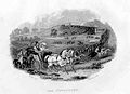
.jpg/120px-Image_taken_from_page_199_of_%27Old_and_New_London%2C_etc%27_(11187526304).jpg) Image taken from page 199 of 'Old and New London, etc' (11187526304).jpg 1,892 × 1,612; 1.11 MB
Image taken from page 199 of 'Old and New London, etc' (11187526304).jpg 1,892 × 1,612; 1.11 MB
-
.jpg/120px-Image_taken_from_page_205_of_%27Old_and_New_London%2C_etc%27_(11192315256).jpg) Image taken from page 205 of 'Old and New London, etc' (11192315256).jpg 2,816 × 1,892; 1.98 MB
Image taken from page 205 of 'Old and New London, etc' (11192315256).jpg 2,816 × 1,892; 1.98 MB
-
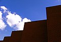 2005-08-28 - United Kingdom - England - London - Notting Hill - Red Brick 4887683035.jpg 2,585 × 1,788; 2.97 MB
-
 48 and 50 All Saints Road, Notting Hill.jpg 4,119 × 3,242; 8.98 MB
-
 54 Basing Street, Notting Hill.jpg 4,454 × 3,385; 9.07 MB
-
 Acklam Road, W10 - geograph.org.uk - 330453.jpg 640 × 480; 124 KB
-
 Allason plan 1823.jpg 957 × 1,194; 1.63 MB
-
 Artists' studios plaque site.jpg 3,000 × 4,000; 4.61 MB
-

-
.jpg/120px-Autumn_Foliage_(Unsplash).jpg) Autumn Foliage (Unsplash).jpg 2,500 × 1,656; 1.75 MB
Autumn Foliage (Unsplash).jpg 2,500 × 1,656; 1.75 MB
-
 Books for Cooks Notting Hill London.JPG 3,343 × 2,850; 2.98 MB
-
 Cafe Diana - London W2.jpg 2,362 × 1,732; 2.13 MB
-
 Cafe Diana - Notting Hill, London.jpg 2,362 × 1,732; 2.61 MB
-
 Cafe Diana behind the Gate.jpg 1,920 × 1,080; 1.86 MB
-
 Caroline Benn blue plaque.jpg 400 × 414; 60 KB
-
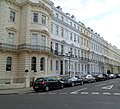
 Chepstow Crescent, Notting Hill, London W2 - geograph.org.uk - 3893461.jpg 1,600 × 1,200; 602 KB
-
 Clarendon Works, 7 Clarendon Cross, Notting Hill, October 2021.jpg 3,024 × 4,032; 4.23 MB
-
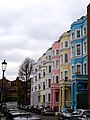
.jpg/120px-Colourful_Notting_Hill_(51050002368).jpg) Colourful Notting Hill (51050002368).jpg 8,368 × 5,584; 30.64 MB
Colourful Notting Hill (51050002368).jpg 8,368 × 5,584; 30.64 MB
-

-
 Environs of London Davies map 1841.jpg 700 × 575; 250 KB
-
 Farm Place, Notting Hill.jpg 6,000 × 4,000; 11.97 MB
-
.jpg/120px-Flat_hunters%2C_Notting_Hill_1974_(1922309790).jpg) Flat hunters, Notting Hill 1974 (1922309790).jpg 2,048 × 1,241; 659 KB
Flat hunters, Notting Hill 1974 (1922309790).jpg 2,048 × 1,241; 659 KB
-
 Football Under The Westway - geograph.org.uk - 420140.jpg 640 × 480; 91 KB
-
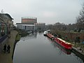 Grand Union Canal, North Kensington - geograph.org.uk - 329861.jpg 640 × 480; 84 KB
-
 Grenfell Road, W11 - geograph.org.uk - 419407.jpg 640 × 480; 159 KB
-
.jpg/120px-In_the_gutter%2C_Notting_Hill_1974_(1922300924).jpg) In the gutter, Notting Hill 1974 (1922300924).jpg 2,048 × 1,371; 574 KB
In the gutter, Notting Hill 1974 (1922300924).jpg 2,048 × 1,371; 574 KB
-
 Kensal Gas Works - geograph.org.uk - 17267.jpg 640 × 480; 101 KB
-
 Kensington hippodrome.JPG 423 × 308; 12 KB
-
 Kensington Park Terrace North - geograph.org.uk - 837153.jpg 640 × 551; 122 KB
-
 Lansdowne House, Lansdowne Road, W11 - geograph.org.uk - 425706.jpg 480 × 640; 130 KB
-
 Lansdowne Road Londres.jpg 4,032 × 3,024; 8.12 MB
-
.jpg/120px-Lion_at_the_Entrance_(6897300821).jpg) Lion at the Entrance (6897300821).jpg 3,264 × 3,264; 1.39 MB
Lion at the Entrance (6897300821).jpg 3,264 × 3,264; 1.39 MB
-
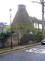 London Bottle Kiln.JPG 1,704 × 2,272; 1.05 MB
-
 NH Enrico2.jpg 2,655 × 3,543; 3.18 MB
-
 No.9 Dawson Place, Notting Hill - geograph.org.uk - 3424126.jpg 4,288 × 3,216; 4.44 MB
-
.jpg/120px-Notting_Hill_(13414475444).jpg) Notting Hill (13414475444).jpg 2,160 × 1,216; 529 KB
Notting Hill (13414475444).jpg 2,160 × 1,216; 529 KB
-
.jpg/90px-Notting_Hill_(2947773318).jpg) Notting Hill (2947773318).jpg 2,112 × 2,816; 3.08 MB
Notting Hill (2947773318).jpg 2,112 × 2,816; 3.08 MB
-
.jpg/120px-Notting_Hill_(2947786158).jpg) Notting Hill (2947786158).jpg 2,816 × 2,112; 2.43 MB
Notting Hill (2947786158).jpg 2,816 × 2,112; 2.43 MB
-
.jpg/120px-Notting_Hill_(2947787838).jpg) Notting Hill (2947787838).jpg 2,816 × 1,584; 2.09 MB
Notting Hill (2947787838).jpg 2,816 × 1,584; 2.09 MB
-
.jpg/90px-Notting_Hill_(2947790126).jpg) Notting Hill (2947790126).jpg 2,112 × 2,816; 2.81 MB
Notting Hill (2947790126).jpg 2,112 × 2,816; 2.81 MB
-
 Notting Hill - geograph.org.uk - 2552.jpg 640 × 442; 50 KB
-
.jpg/120px-Notting_Hill_Carnival_2017_(36043010863).jpg) Notting Hill Carnival 2017 (36043010863).jpg 5,472 × 3,648; 2.92 MB
Notting Hill Carnival 2017 (36043010863).jpg 5,472 × 3,648; 2.92 MB
-

-
 Notting Hill.JPG 3,872 × 2,592; 2.55 MB
-
_(14798353713).jpg/120px-Old_and_new_London_-_a_narrative_of_its_history%2C_its_people%2C_and_its_places_(1873)_(14798353713).jpg)
-
_-_geograph.org.uk_-_421093.jpg/120px-Outside_Latimer_Road_Underground_Station_(1)_-_geograph.org.uk_-_421093.jpg)
-
_-_geograph.org.uk_-_421098.jpg/120px-Outside_Latimer_Road_Underground_Station_(2)_-_geograph.org.uk_-_421098.jpg)
-
 Robinson House, Bramley Road, W10 - geograph.org.uk - 420130.jpg 640 × 480; 143 KB
-
.jpg/120px-Rude_boys%2C_Notting_Hill_1974_(1922313268).jpg) Rude boys, Notting Hill 1974 (1922313268).jpg 2,048 × 1,371; 534 KB
Rude boys, Notting Hill 1974 (1922313268).jpg 2,048 × 1,371; 534 KB
-
.jpg/90px-Rum_Kitchen%2C_Notting_Hill%2C_W11_(41344046251).jpg) Rum Kitchen, Notting Hill, W11 (41344046251).jpg 1,988 × 2,650; 1.94 MB
Rum Kitchen, Notting Hill, W11 (41344046251).jpg 1,988 × 2,650; 1.94 MB
-
-
 Tavistock Road, W11 - geograph.org.uk - 330489.jpg 640 × 480; 126 KB
-
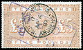 Telegraph stamp.jpg 2,744 × 1,658; 952 KB
-
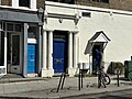 The famous blue door of Notting Hill.jpg 4,032 × 3,024; 3.2 MB
-
 The Kensington Hippodrome, 1841.png 474 × 464; 490 KB
-
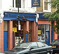 Travel bookshop.jpg 1,794 × 1,635; 706 KB
-
 Treadgold Street, W11 - geograph.org.uk - 421509.jpg 640 × 480; 119 KB
-
 St Marylebone Infirmary, Exmoor Street, London; the exterior Wellcome V0013613.jpg 3,340 × 2,276; 4.31 MB
-
 Waynflete Square, W10 - geograph.org.uk - 420169.jpg 640 × 480; 139 KB
-
 Westway Sports Centre - geograph.org.uk - 420156.jpg 640 × 480; 79 KB
.jpg)
.jpg)


.jpg)


.jpg)


.jpg)


.jpg)


.jpg)


.jpg)
.jpg)
.jpg)
.jpg)
.jpg)

.jpg)


_(14798353713).jpg)
_-_geograph.org.uk_-_421093.jpg)
_-_geograph.org.uk_-_421098.jpg)

.jpg)
.jpg)


